- +40-700-123-4567
- email@example.com
- 14th Street, New York


Where is Taiz governorate located?
The governorate of Taiz is located in the southwestern part of the Republic of Yemen, between latitudes (12-14) north of the equator and between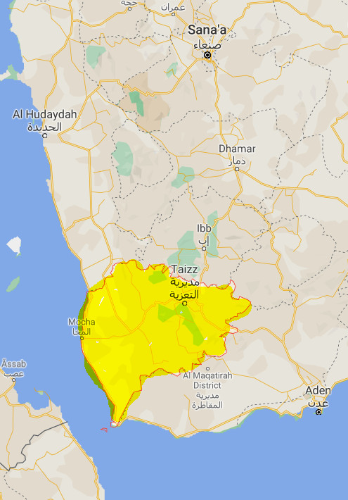 longitudes (45-43) east of Greenwich. It is about 256 kilometers from the capital, Sana'a. The governorate is connected to the governorates of Ibb and Al Hudaydah from the north, parts of the governorates of Lahj, Al Dhale'e and Ibb from the east, Lahj governorate from the south and overlooks the Red Sea from the west.
What is the size of Taiz Governorate?
The area of the governorate is about (12,506) square kilometers, distributed into twenty-three districts, according to the administrative division of 2004.
What is the population of Taiz governorate?
Taiz governorate ranks first in terms of population according to the results of the 2004 census, with its population amounting (2,393,425) and forming (12.16%) of the total population of Yemen. The population annual growth rate is (2.47%).
What are the districts of Taiz governorate?
The governorate is divided into (23) districts according to the last administrative division as follows:
- Al Makha District
- Al Ma'afer District
- Al Mawasit District
- Al Misrakh District
- Al Mudhaffar District
- Al Qahirah District
- Al Wazi'iyah District
- As Silw District
- Ash Shamayatayn District
- At Ta'iziyah District
- Dhubab District
- Dimnat Khadir District
- Hayfan District
- Jabal Habashy District
- Maqbanah District
- Mashra'a Wa Hadnan District
- Mawiyah District
- Mawza District
- Sabir Al Mawadim District
- Sala District
- Same District
- Shara'b Ar Rawnah District
- Shara'b As Salam District
What are the major tourist and historical attractions in Taiz governorate?
There are various archaeological and historical monuments in the governorate, which include:
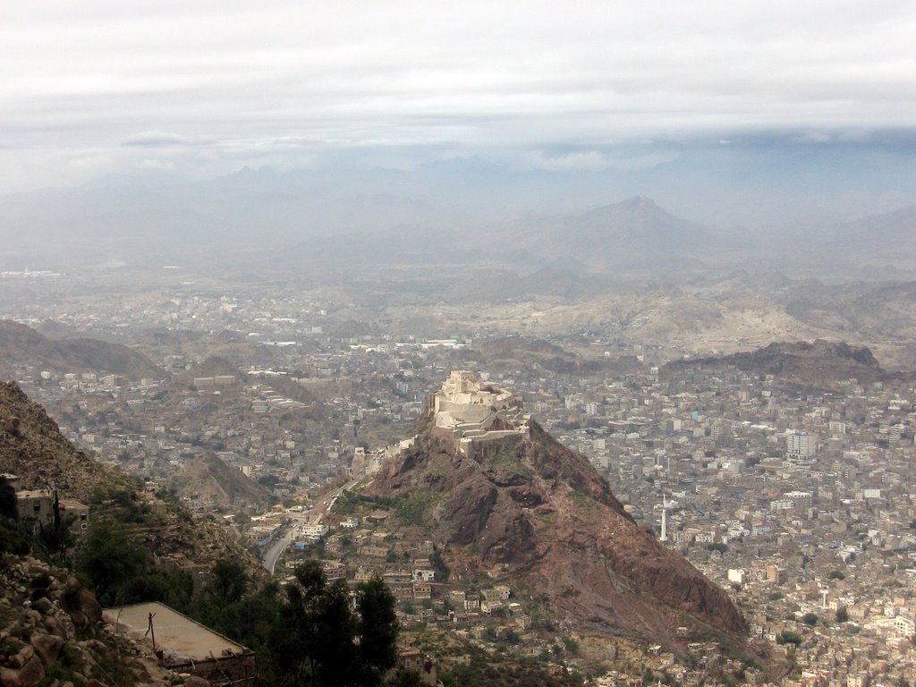
Al-Bab Al-Kabeer, Bab Musa, Al-Muzaffariyah School, Al-Ashrafiya School, Al-Atabekiah School, Al-Husseiniya Dome, Al-Qahirah Castle, Sabr Mountain, Sheikh Zayed Park, Al-Gharib Tree, Sala Palace, Al-Imam Palace, Muaz Bin Jabal Mosque, Ahl Al-Kahf (People of the Cave) Mosque, Al-Qadam Fort, Mayyun Island in the Strait of Mandeb, Muneef Fort, Lulwa (Pearl) Mountain.
What is the climate of Taiz governorate?
Taiz Governorate has an extraordinarily diverse geography. The western half of the governorate is part of the Tihama coastal plain, which is characterized by a very hot, humid and dry climate. However, the eastern half is very mountainous, with the main peak being 3,070 meters high at Jabal Sabir, near the city of Taiz. Temperatures in the highlands remain high during the day, but at the highest altitudes they can drop drastically to -5 °C (23 °F) overnight.
Sources:
- Central Statistical Organization, 2006
- Wikipedia - National Information Center (Arabic)
- HUMAN ACCESS (Media Center)
- Yemen figures and facts (the National Information Center).
- Results of the tourism survey during the period from (1996-1999)
